Monday, May 30, 2011

High Water along the Atchafalaya and Mississippi Rivers, May 2011

As I described in the previous article, the Atchafalaya River carries 30 percent of the combined flow of the Mississippi and Red Rivers. In times of flood, more than 30 percent may have to be diverted to prevent levees being overtopped in Baton Rouge and New Orleans.


One of the towns subject to high water is Melville, Louisiana. The first photograph shows the landing for the former Melville-Pointe Coupee ferry service, which permanently closed in December 2010. Dump trucks were rumbling past to a site just south of the landing, where the levee was being elevated. The second photograph shows how high the water was under the railroad bridge, 14 May 2011.


Morgan City is a historic town near the Gulf of Mexico mouth of the Atchafalaya. Having suffered from many floods in the past, the Corps of Engineers built a levee and floodwall system around the town in 1926. The concrete floodwall is a popular tourist attraction because you can look down on the Atchafalaya on one side and down on the historic city on the other. Normally there are a boardwalk and docks on the river side, but this time, the river was well above the base of the floodwall (15 May). The bridge in the background is US 90


Finally, New Orleans. The levees have been reinforced since Hurricane Katrina and raised in some areas. Along the French Quarter, the levees were well above the water level, even under conditions of the 2011 flood. For tourists, it was a great opportunity to be photographed next to Ol' Man River (or The Big Muddy).

(Photographs taken with an Olympus E-330 camera and Olympus 14-54mm f/2.8 lens)

Saturday, May 21, 2011

Where does the Water Go? The Old River Control Structures, Louisiana

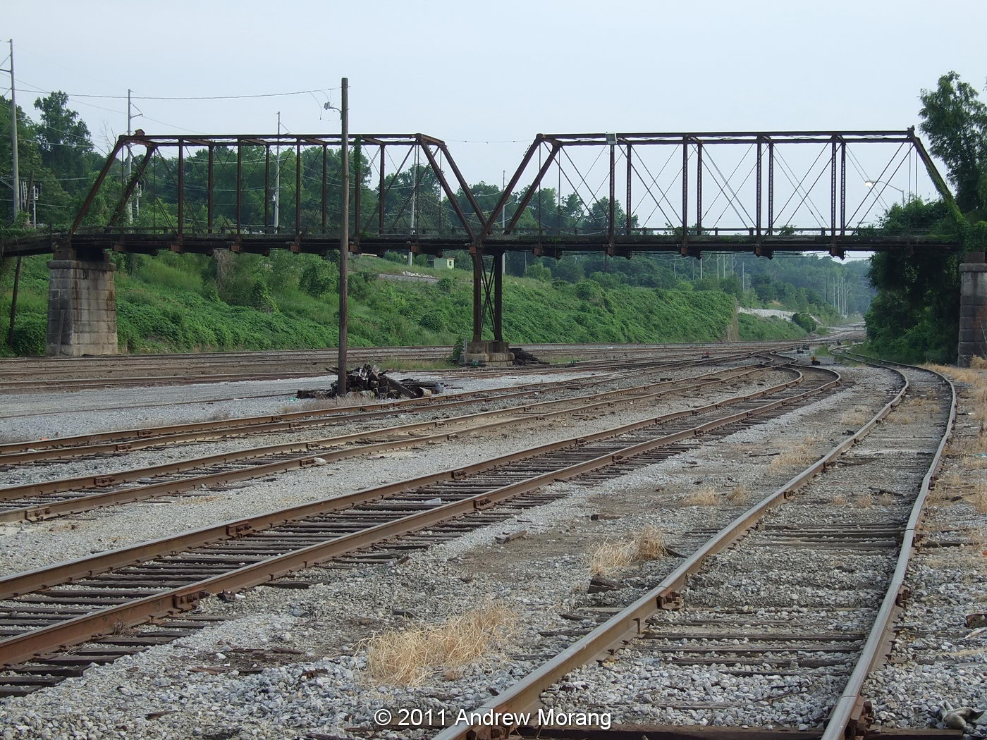
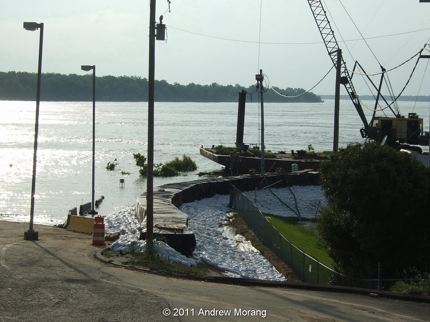
Introduction.  The 2011 Mississippi River flood brought the news media to towns like Memphis, Vicksburg, and Natchez. But although they showed photographs of wet homes, they did a shallow coverage of the river, its flow, and water control, and explaining what happens to the water and sediment and why our economy depends critically on this control. It is a complicated topic, but I will try to summarize why the US Army Corps of Engineers built and operates major hydraulic structures at Old River, Louisiana, and show some photographs.
Mississippi River drainage area (from US Army Corps of Engineers). Pink shows the area protected by the Mississippi River &Tributaries Project
Background. "The Mississippi River has the third largest drainage basin in the world, exceeded in size only by the watersheds of the Amazon and Congo Rivers. It drains 41 percent of the 48 contiguous states of the United States. The basin covers more than 1,245,000 square miles, includes all or parts of 31 states and two Canadian provinces, and roughly resembles a funnel which has its spout at the Gulf of Mexico. Waters from as far east as New York and as far west as Montana contribute to flows in the lower river." (from US Army Corps of Engineers).

Before the mid-1800s, the Red River joined the Mississippi about 45 miles northwest of Baton Rouge, Louisiana, at latitude 31.1 degrees north. By definition, the Red was a tributary because it added its water to the main river. Just a short distance to the south, some water diverted off the main channel into the Atchafalaya River, which carried the flow to the Gulf of Mexico. Therefore, the Atchafalaya was a distributary because it carried water away from the main channel.
From US Army Corps of Engineers
In the early 1800s, the Atchafalaya only carried a small percentage of the total flow because it was clogged with immense rafts of logs and debris. But starting in the mid-1800s, the Corps of Engineers and State of Louisiana methodically cleared the logs to open up the channel for navigation and commercial development. Clearing log jams on Western rivers was one of the Corps' earliest civil works missions.

By the early 20th century, the Atchafalaya had been cleared and dredged to create a Federal navigation project. Dredging continued to improve navigation. But, a serious problem developed: during the early years of the 20th century, the Atchafalaya channel naturally scoured (became deeper) and proceeded to capture an ever greater percentage of the Mississippi's total flow. The reason was geological: The distance from Old River to the Gulf of Mexico via the present river channel past Baton Rouge and New Orleans and ending at the present Balize delta was about 300 miles, while the distance along the Atchafalaya waterway was only 140 miles. This meant the new route was steeper and therefore more efficient. From 1880-1950, the percentage of Mississippi water flowing down the Atchafalaya increased from 7 to over 25 percent, and river hydrologists predicted that by the 1970s, the Atchafalaya would capture almost all the flow (Reuss, 2004). Under natural conditions, this type of channel shifting occurred about every 1000 years, but for a modern industrial economy, such a shift would have disastrous economic consequences.

Consider what might happen: New Orleans would lose its fresh water supply. The many petrochemical plants and the nuclear power plant on the river between Baton Rouge and New Orleans would lose water supply. It might be close to impossible - or vastly expensive - to maintain a deep-draft navigation channel suitable for ocean-going vessels to reach Baton Rouge. Note: Baton Rouge is now a deep-draft port, meaning one suitable for ocean-going vessels. The reason this is possible is the scouring action of the Mississippi flow, which flushes much of the sediment load out to sea, leaving a deep channel.

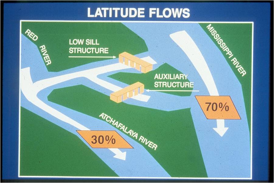
In the 1954 Flood Control Act, Congress authorized the Corps of Engineers to build structures to control the flow of water down the Atchafalaya. The Act also authorized future appropriation for navigation locks. The flow was to be maintained at 30 percent of the total at that latitude. This is complicated to compute because it includes the input from both the Mississippi and Red Rivers. Therefore, the diversion from the main trunk of the Mississippi is somewhat less than 30 percent, depending on how much water is coming down the Red. The following figure shows what Congress intended.
From US Army Corps of Engineers
Presently, "The Old River Control project consists of several large engineering structures. These structures include the Old River Low Sill and Overbank Structures that began operation in 1962; the Old River Lock completed in 1963; and the Auxiliary Structure built in 1986." (From US Army Engineer District, New Orleans, web page.) The lock is necessary because often the Red and Mississippi are at different levels, and the lock lets barges transit from one river to the other. Adding to this complex, in 1990, the Sidney A. Murray, Jr. Hydroelectric Station was built to generate electricity using turbines.

Photographs.  Driving south on Louisiana 15, which follows the levee along the west side of the Mississippi, the road crosses a bridge at the Sidney Murray station, then crosses the Overbank Structure, and finally reaches the Low Sill Structure.

Upstream side of the Sidney A. Murray hydroelectric plant. This 2009 photograph was taken at low water. The intakes for the turbines are way below the water level and there is little to see for the casual visitor..

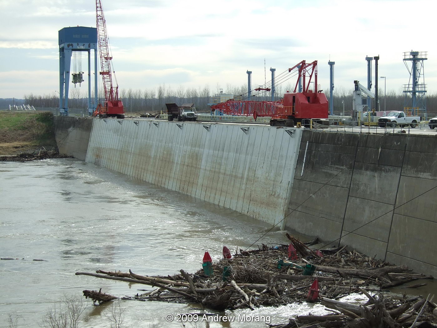
The downstream side of the Overbank Structure at low water on January 19, 2009.

One of the bays in the Overbank Structure. During floods, wood boards or batons can be lifted one by one to control the flow of water. In the 2011 flood, leakage past the boards amounted to about 50,000 cubic feet per second (cfs).

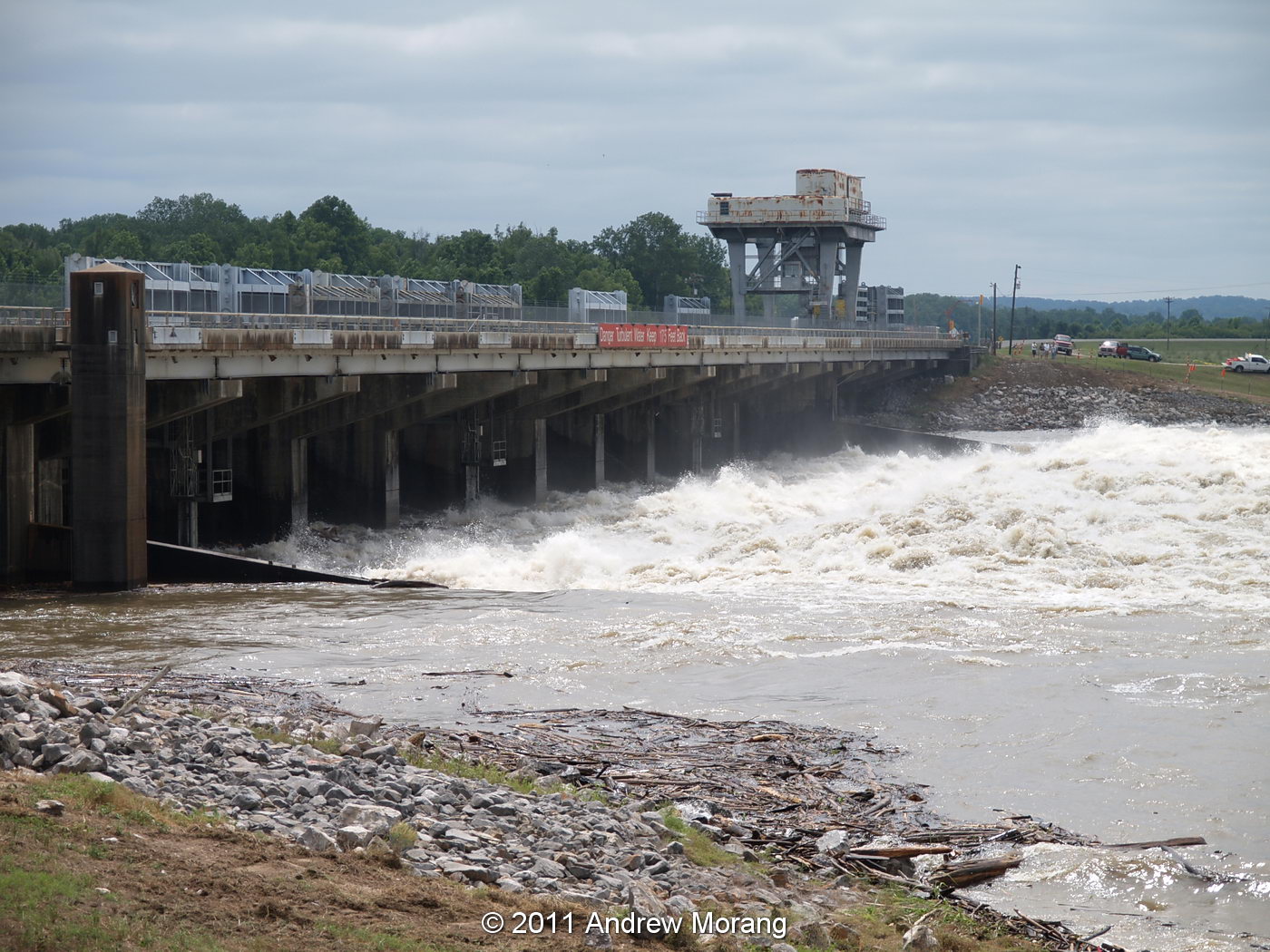
Downstream side of the Low Sill Structure, 14 May, 2011, with flow of approx. 200,000 cfs.

The upstream side on the Low Sill structure. Water this high is a very rare event; it may be decades before we see it as high again. During the flood of 1973, a great scout hole formed on the south side of the structure (the far side in this photograph). Engineers feared the structure might collapse, which would have led to the abrupt switching of water flow down the Atchafalaya waterway. If this had happened, a new structure could have been built in summer, when the water was low, but it would have been technically difficult and very expensive. Congress would have had to appropriate emergency funds. Months of excess flow down the Atchafalaya waterway would have caused many economic, sedimentological, and environmental consequences.

The vertical panels are the gates. A crane moves along a track, and the operators raise or lower the panels into the concrete slots in the dam. The amount of water is controlled by how high the panels are above the concrete bottom. Water flowing along the bottom of the concrete channel flushes sediment through the system into the outlet canal and, ultimately, into the Atchafalaya.

The next structure to the south is the Auxiliary Structure. This was built after the 1973 flood almost destroyed the Low Sill Structure and engineers realized that that another structure was needed to channel some of the water to the Atchafalaya. Construction began in 1981 and was completed in 1986.

Downstream side of the Auxiliary Structure, 14 May 2011.

One of the the six tainter gates. These are steel arches fixed to trunnion blocks and lifted by steel cables. In this photograph, the gates are up 23 ft, resulting in total flow of 230,000 cfs. These gates can be controlled more precisely than the rectangle steel panels used in the Low Sill Structure.

The operators have to coordinate with the hydroelectric plant to adjust the water flow through all the structures. On May 19, the Mississippi was flowing at about 2,000,000 cfs, so the hydro plant, Overbank, Low Sill, and Auxiliary released about 600,000 cfs to the Atchafalaya, maintaining the 30/70 percent ratio.

Wood and flotsom get jammed up against the gates, and the raft often contains some interesting cargo. The cables hold up the gates and go up into the structure to heavy-duty electric winches.


The morning I visited, the gate operators and a ranger hoisted up a boar that had gotten stuck on the log raft. They said they were going to feed him corn for a few weeks. Sounds like an upcoming BBQ and plenty of bacon.

References

For a long but engaging description of the topic, I suggest a February 23, 1987 New Yorker article by John McPhee titled "The Control of Nature, Atchafalaya": Control of Nature

A shorter summary was written by Alexis Madrigal for a May 19, 2011 article in The Atlantic:
What We've Done

For a more scholarly treatment: Reuss, M. 2004. Designing the Bayous, The Control of Water in the Atchafalaya Basin, 1800-1995. Texas A&M University Press, College Station, TX, 474 p.

Acknowledgments

Thank you to New Orleans District Corps of Engineers and the operators of the Old River Control Structure for hosting tour groups from the Waterways Experiment Station in 2009 and 2011. We appreciate the time they took to show us around.

Thursday, May 19, 2011

The Day the Water Crested in the 2011 Mississippi River Flood: North Vicksburg

Map of road closures and inundations. From The Mississippi River Flood of 2011, A Publication of The Vicksburg Post (© 211 Vicksburg Post)

The Mississippi river crested on Thursday, May 19, 2011 at 57.1 ft. on the Vicksburg gage, 1.1 ft. higher than the crest during the great 1927 flood. If the levees had held, the 1927 crest would have been higher, but as measured, the level was 56.0 ft at Vicksburg. In this year's flood, the Kings neighborhood in north Vicksburg was one of the wettest areas of town. In a few places, the water was right at the base of North Washington Street. In previous floods, like the one in 2008 (crest 50.9 ft.), water remained west of the railroad tracks, which served as a form of levee.

Some good news: The Waltersville Estates, operated by Vicksburg Housing Authority, just missed getting water in the ground floor units. I think no one needed to be evacuated.

Further north, conditions were much messier. This church and house are near the intersection of Hutson and North Washington Streets.

Look west along Hutson Street, and all you see is water.

In all, more than 2000 people were displaced in Vicksburg, according to the Vicksburg Post. I think most were from this low-lying area north of Vicksburg. The water is predicted to remain at this level for at least three days and slowly - very slowly - start to recede. Public Radio has already started warning people to wear protective clothing when they enter flooded homes, and the county is offering free tetanus inoculations. Rangers are on duty to help remove snakes and alligators.

Update June 19, 2011. According to the Vicksburg Post (from county and Federal sources):
  • Evacuations from Vicksburg and Warren County: 3,202
  • Structures evacuated county-wide: 1,340
  • Homes inside Vicksburg flooded: 185-200
  • Acres flooded in Warren County: 150,165
  • River flow during week leading up to crest: 2.15 million cu ft/sec (highest ever recorded)
(Photographs taken with an Olympus E-330 digital camera.)

Wednesday, May 18, 2011

Close to the Crest, the Waterfront at Vicksburg, Mississippi


By Monday, May 16, the water had risen about 1.5 ft above the Friday level. It was 56.66 ft at 15:00, above the 1927 record. At the historic 1907 depot, water reached the ground floor windows. A week ago, someone bolted plywood panels in front of the doors and windows, but they had not been sealed with any caulk or gaskets, so it was an effort too late and too rushed.

Further north, water covered the entire dirt field north of the M/V Mississippi (compare with the photograph in the previous entry). I saw a snowy egret walking around looking for yummy worms and bugs, so at least some wildlife has been able to adapt. Tourists have adapted, too: I have never seen so many visitors downtown.

Here is some information on the Vicksburg Gage from the Corps of Engineers RiverGages.com:

Mississippi River at Vicksburg, MS
Stream Name: Mississippi River
Gage Zero: 46.23 Ft. NGVD29
Flood Elevation: 43.0 Ft.
Record High Elevation: 56.0 Ft.
Longitude: -90.90233200 Latitude: 32.31183200
River Mile: 435.7
Record High Elevation Date: 05/04/1927

Location of Gage: 1.6 miles downstream of the mouth of the Yazoo Diversion canal. Vicksburg Quandrangle.

Note that the level of 56 ft was as measured. If the levees had not failed at various locations along the basin, particularly at Greenville, the 1927 level would have been several feet higher. I believe the Vicksburg concrete floodwall was built to this higher stage. In effect, there is a considerable factor of safety built in to the Vicksburg walls.


This is the view of the waterfront south of the Depot on May 3, 1927, showing the old, lower floodwalls. The photograph is from the collection of the Mississippi Department of Archives and History, and is labeled:

1927 Flood Photograph Collection
"Vicksburg, Miss. 5-3-27." Flooded street and railroad tracks. Pedestrians and steamship in background.

Monday, May 16, 2011

North Washington Street Inundation in the 2011 Mississippi River Flood


By Friday, May 13, the level of the Yazoo Canal was high enough to be creeping across a low spot on North Washington Street, and the police had to block it off. This is the view north at the junction of First East and Washington Streets. Morning elevation: 55.5 ft (based on the Vicksburg gage).

(Postscript May 19, 2011: A 69-year-old Vicksburg man drowned here. City workers found the body near the flooded intersection.)

This is the view looking southwest towards the casino (May 13). The boat on the left up on a concrete platform is the MV Mississippi, the former Corps of Engineers inspection and work boat. It will become the centerpiece of the Mississippi River interpretative center. I have old photographs of railroad tracks running into this lot, but they had not been used for at least three decades. Also, years ago, a coal company was located here.

Once again, let me remind readers of the excellent historical flood photographs on the Mississippi Department of Archives and History's web page:
http://mdah.state.ms.us/arrec/digital_archives/1927flood/

Friday, May 13, 2011

As the Water Rises (2011 Mississippi River Flood): the Yazoo Canal in Vicksburg

South of the Vicksburg waterfront and landing (seen in the previous blog entry), the concrete floodwall continues south about one mile past a Bunge Corp. grain facility and the Kansas City Southern railroad yard. This is usually a bustling place with hundreds of rail cars on the tracks, locomotives being rebuilt or fueled, and workers moving about. On Thursday, May 12, the rail yard was deserted, absolutely quiet. I was astonished. The railroad moved all their rolling stock out in case the worst happens and the levees or floodgates fail. Proceed further south and the concrete floodwall ends past the now-deserted Vicksburg Compress (topic of a future article). It becomes an earthen levee at a refinery, makes a turn, and ends at the railroad tracks. The two photographs above are looking southwest towards the Mississippi River. Dorsey Street is somewhere in the water. I saw a lot of bubbles and splashing in the water. Two dogs looked like they were catfish fishing. You can drive south along a gravel road that parallels the tracks, you soon reach the Ergon Marine & Industrial Supply Dock. Diamond Jacks Casino, just to the south, closed, but Ergon built a temporary levee to keep the water out. It consists of some sort of sand-filled cribs with plastic sheeting and thousands of sand bags to secure the sheeting. What a job it will be to remove all this material later this summer. In Friday's Vicksburg Post, a guard at the Diamond Jacks parking lot said he saw boars (you know, big nasty hairy pigs) coming out of the water. Vicksburg police evacuated the city front park. (Poscript May 20, 2011: The levee around the Ergon dock failed and the area on the right side of the photograph above filled up with water.)

Thursday, May 12, 2011

Stop Log Flood Gates in Vicksburg

Friends and coworkers have expressed interest in the temporary flood gates that the City of Vicksburg workers install to hold back the water. The concrete floodwall lines the Yazoo Canal along the Vicksburg waterfront. It runs from near the mouth of the canal (where it enters the Mississippi River) northward to Grove Street, then turns east and ends as Grove Street runs uphill.

There are several gaps in the floodwall to allow access to the river. The widest gap is where Levee Street runs north-south at the Grove Street junction. The railroad tracks also run through here. To block this opening, the city workers have to cut the tracks, dig up part of the pavement, and install steel I-beams. They have to dig up the street each time they anticipate a flood high enough to need the temporary barriers. It's a bit clumsy because afterwards, they have to repave the street. I expect they fill the hole with dirt and just add a thin layer of asphalt. Wood beams (stop logs) are placed in the I-beams and sealed with tar and oakum. In this photograph, you can see the 1907 railroad depot on the wet side of the barrier and can see a section of railroad track that was removed.


The temporary barrier is simple and effective against low flood levels. I have seen it hold back a half meter of water. This will be the test to see how it works with 2 m! Some water seeps through and pumps move the runoff back over the concrete wall some distance to the south (near the casino).


This last photograph shows Grove Street. Most of Vicksburg is on the bluffs and therefore safe from flooding. Compared to the early 1900s, when the entire Vicksburg waterfront was lined with shops, foundries, ship chandlers, and manufacturing plants, there is less at risk now if the waterfront were to be inundated.

Tuesday, May 10, 2011

Before the Crest: the Great Mississippi River Flood of 2011 in Vicksburg

The water is rising and, as of May 10, 2011, has exceeded all historical river elevations in Vicksburg. Fortunately, unlike a tsunami situation, there has been plenty of warning about the approach of the flood crest and industries and the City of Vicksburg have been preparing.

The Anderson Tully wood products company was inundated in the 1973 flood. A retired worker told me that it took five years to dry out the timber. To prevent future flooding, the company built a levee around the mill after 1973. But for the last week, a fleet of trucks has been delivering dirt and clay, and the levee is being extensively raised. The photograph above was Sunday, May 8.

Redwood Elementary School, in Redwood, north of Vicksburg, was vulnerable to water backing up a creek that runs behind the school. To protect it, the school department hired a contractor to build a levee. This was a significant berm, over 2 m high for much of its extent.

The students evacuated the school and will finish the year at another facility. They piled books and materials in the auditorium (Friday, May 6).

Most of Vicksburg was built on the loess bluffs, high above the river. The city waterfront, where steamboats unloaded and warehouses were located, historically flooded. To protect the waterfront, the Corps of Engineers built concrete flood walls early in the 20th century and greatly expanded them after the 1927 flood, which overtopped the earlier walls. But roads and railroads need to pass through the wall in several locations. These gaps in the walls are plugged with wood timbers held in place by steel I-beams. The city workers have to dig down into the pavement to find the anchor points for the I-beams. The timbers are sealed with oakum and tar and chained down (Friday, May 6). Later, the city workers found that plastic sheeting was more effective at preventing seepage.

I have never before seen the timber walls installed to their full height, flush with the concrete walls. The timbers have never been tested to hold back three meters of water. The gate above is at Levee Street near the old railroad depot. Sadly, the depot, which is being renovated to become part of the river museum, is on the unprotected side of the flood wall.


The Ford subdivision off North Washington Street has been prone to flooding for decades. Over the last five years, the City has bought many of the low houses (the ones built on slabs) and demolished them, but there are still many residents who have to evacuate. The views above are from Railroad Alley, taken Friday, May 6.

The car, which is rapidly losing its patch of pavement, is on Eva Street (Friday, May 6).

This is Ford Street, looking towards the west (Friday, May 6). In previous inundations, residents told me that cleanup was always a messy business, and they had to call the rangers to take away snakes and alligators.
Across the river in Delta, Louisiana, this is the view from the levee facing east towards the old Mississippi River bridge. Normally, the terrain in the foreground is dry. The bridge still carries Kansas Southern Railroad trains, but the automobile road is closed.

Please see the subsequent blog articles to read about the progress of the historic 2011 flood.