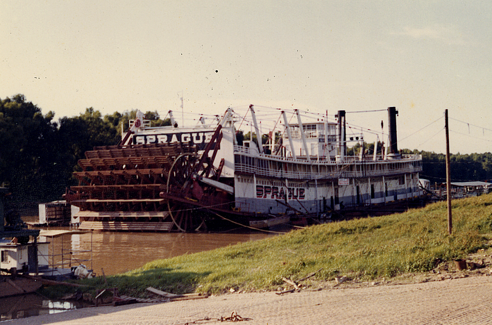
Sunday, January 24, 2016

Quiet along the tracks, Bentonia and Flora, Mississippi

Bentonia is a small town in Yazoo County off Highway US 49, about 28 miles northwest of Jackson, Mississippi. The community grew up as an agricultural and postal town along the Illinois Central Railway tracks, which are on the main line between Jackson and Yazoo City. On an overcast November day in 2010, while driving from Yazoo City to Flora, I decided to pull off in Bentonia and look around. It was pretty quiet; not much was happening.
These shops on West Railroad Avenue were closed on the late afternoon when I took the photographs.
Across the tracks on East Railroad Avenue is the famous Blue Front Cafe, a juke joint that played an important role in the Blues tradition and the origin of the "Bentonia Blues." A 2006 USA Today article described the cafe.
Next to the Blue Front was a car repair shop occupying a former cotton gin shed.
The next town south (towards Jackson) is Flora. It also has the look of snoozing the decades away.
These two shops looked unused, especially the sports bar with the bush in front of the door.  Jackson is only a few minutes south on 49, and I suppose most local residents of Flora work and shop in the city. Small-town businesses have a hard time competing.

Photographs taken with a Fujifilm GW690II medium-format rangefinder camera on Kodak Panatomic-X film, developed in Agfa Rodinal developer at 1:50 dilution. I scanned the negatives on a Minolta Scan Multi scanner, cleaned lint and other marks with Faststone, and enhanced contrast and exposure with PhotoNinja software. Click any of the photographs to see a larger version.

Monday, January 18, 2016

Into the Woods: Morgan City, Mississippi

Right after Christmas 2015, my daughter, some friends, and I participated in the Audubon Society's annual Christmas bird count on the Sidon, Mississippi, count circle. I had never been there before and did not know the terrain. South of the nearby town of Morgan City (the town in Mississippi, not the city on the Atchafalaya River in Louisiana) are farm fields and remnant patches of bottomland hardwood forest.
We pulled off into a patch of woods to look for birds. There was a collapsed house there, in itself not too unusual. The former occupant left some vehicles behind. The first was an International Harvester truck. This was one of the Loadster series, which ended production in 1979. International Harvester is now known as Navistar International Corporation.
More interesting was a first generation Ford Bronco (1966-1977). This was Ford's small SUV, intended to compete with the Jeep CJ models and the International Harvester Scout.
This was a fairly rustic, basic utility vehicle, which is still respected by serious off-roaders. Notice this example had automatic transmission. Also look at the three knobs to the right of the steering wheel, of which the rightmost one is pulled out. I assume this was either the choke for the carburetor or to operate a vent damper door. Simple but effective, unlike the über-complex electronic nightmares you see in contemporary cars.
There was not much left to the house. This is the fate of wood structures in a humid environment.

Photographs taken with a Fujifilm X-E1 digital camera and the 18mm f/2.0 lens. RAW files processed in PhotoNinja software.

Friday, January 15, 2016

Rest in Peace: Remnants of the "Sprague", Vicksburg, Mississippi

The towboat "Sprague," known as the "Big Mama," was the most powerful and high-capacity sternwheel river boat to ply the Mississippi River. A Mississippi vessel is known as a tow, but really it serves as a pusher, where the powered unit pushes a series of barges up- or down-river. The photograph above, from Mississippi Department of Archives and History, shows the massive stern paddle wheel that would push the entire tow.
This is a 1946 photograph from the Standard Oil (NJ) Collection, Photographic Archives, Archives and Special Collections, University of Louisville.

Southern View wrote about the Big Mama. Some statistics from Wikipedia:
Type:Towboat
Length:276 ft (84 m)
Beam:61 ft (19 m)
Draft:7.4 ft (2.3 m)
Installed power:2,079 horsepower (1,550 kW)
Propulsion:coal-fired steam
The "Sprague" was in operation from 1902 to 1948. After it was decommissioned, it served as a museum on the Vicksburg waterfront. For decades, the Mississippi River melodrama, "Gold in the Hills" was performed onboard. The boat burned at dock on 15 April 1974 under the usual mysterious circumstances. There were plans to restore part of it, but they never came to fruition. Because it was a hazard to navigation on the Yazoo Canal, the hulk was dynamited. Some of the metal remains lay in the dirt and woods just west of North Washington Street for decades. Some bollards or capstans were moved to the Catfish Row playground on Levee street. A few more parts and and the rudder are in the parking lot next to the Klondike restaurant on North Washington Street.
But the largest metal bits are still in the thickets next to the Yazoo Canal. It is easy to reach the site, and there are no "no trespassing" signs. These two photographs show stacks and some unknown tubing.
 Some of the pipe joints have crumbling asbestos.
The boilers must have been quite impressive when intact. Note the bee holes in the packed mud.
Most of these parts are hard to see in summer, when the vines and poison ivy engulf everything. I don't understand why they have not been taken to Catfish Row, where tourists could see how mighty the "Sprague" was once.

These digital images are from a Fujifilm X-E1 digital camera with Fuji 18mm f/2 lens. I processed the RAW files with DxO Filmpack 5 with the Kodak Tri-X or Agra Scala film emulations. They still do not look like real black and white film photographs, so next time I'll return with film.

For more historical photographs and scans of one of the programs, please click this link.

Sunday, January 10, 2016

Decay within sight of the State Capitol, Jackson, Mississippi

I have always been surprised how a run-down neighborhood can be only a few blocks away from a major commercial or government area. I first encountered this in Houston, where slum houses in the Fourth Ward had a view of the glamorous glass office buildings of downtown. I had not encountered this type of urban disparity in European or New England cities. Jackson fits the pattern: just west of the state capitol, slum neighborhoods are rough and being abandoned or torched.
George Street is (or was) a mess. I have not been back since I took these photographs in 2011, and many of these shotgun shacks have likely been demolished.
East Church Street, a block north of George street, was just as dilapidated. This is a photographer friend checking an abandoned house.
These were once nice residential neighborhoods. Unfortunately, I am not surprised they were allowed to decay. Jackson is in rough shape, and you readers know many of the reasons (I won't list them because this is not a political blog). When the houses are razed, the property no longer serves as a tax source. Less tax revenue means city services, infrastructure, and schools deteriorate, which leads to more people abandoning their properties and moving to more prosperous communities. The blight spirals - the race to the bottom that we see in so many American cities. It is absolutely disgusting.

Photographs taken on Kodak Panatomic-X film with a Fuji GW690II rangefinder camera (the "Texas Leica"). I developed the film in Agfa Rodinal developer at 1:50 dilution and scanned the negatives with a Minolta Dimage Scan Multi medium format scanner.

Friday, January 8, 2016

Lost flood zone houses: Marys Alley, Vicksburg, Misissippi

As of January 2016, another flood is surging down the Mississippi River. The high water, predicted to be about 52 ft above gauge zero on the Vicksburg gauge, will inundate low-lying areas west of North Washington Street. The 2011 flood reached 57.1 ft, a record, but even at only 44.6 ft, the Kings subdivision, located north of the Anderson-Tully Vicksburg sawmill, is subject to some degree of inundation. As a result, residents of homes built on ground level have often needed to evacuate, and the homes were repeatedly damaged. Finally, many of these low houses were purchased and removed via a FEMA program. As of 2012, all the houses along Marys Alley were gone. Click the link to see an aerial photograph from an older post.
These little houses were pretty rough by the time they had been condemned. I guess they were 1940s vintage, semi-shotgun style. They were elevated off the ground a few feet and probably had survived several high water events. But some other houses in this area were 1960s- or 1970s-vintage with slab foundation. A slab house in a flood-prone area?

These are scans of 120-size Kodak Panatomic-X film, exposed with a Fuji GW690II camera with 90mm EBC Fujinon lens. The camera was tripod-mounted. I scanned the negatives with a Minolta Dimage Scan Multi medium format film scanner.

The following list shows historic crest levels at the Vicksburg gauge, from the National Weather Service:

Historic Crests
(1) 57.10 ft on 05/19/2011
(2) 56.20 ft on 05/04/1927
(3) 53.20 ft on 02/21/1937
(4) 52.80 ft on 06/06/1929
(5) 52.50 ft on 04/28/1922
(6) 51.60 ft on 05/13/1973
(7) 51.50 ft on 02/15/1916
(8) 51.00 ft on 04/20/2008
(9) 50.20 ft on 04/16/1897
(10) 49.90 ft on 04/27/1913

And here are some low water records. You can see that the total water level range can be as much as 64 feet.

Low Water Records
(1) -7.00 ft on 02/03/1940
(2) -6.80 ft on 11/01/1939
(3) -5.80 ft on 01/06/1964

Wednesday, January 6, 2016

Lost Small-town Store: Main Street, Vicksburg, Mississippi

For much of the 20th century, many people did not have automobiles, and all towns had local stores to supply staples and groceries. Vicksburg had many of these small stores, but most have disappeared over the years. Williams Gro was at 1620 Main Street. I recall seeing the little shop, but it had been closed for years.
Finally in 2010, the city inspector condemned it along with the house next door. Oddly, both had the address 1620. The spray paint number is the indication that the building has been condemned and that the backhoe will soon crush the hulk.    
Note the Winston sign indicating opening hours and the Holsum bread sign. Holsum had a distributor in Vicksburg years ago.

Technical note: I recently bought an early-2000s Minolta Dimage Scan Multi medium-format scanner. With some manipulation, I got it to work on a Windows 7 computer. I have started testing it with my 6x9 cm 120-size Kodak Panatomic-X negatives, which I expose in a Fujifilm GW690II rangefinder camera (also sometimes known as the "Texas Leica"). This is a big beast of a camera with an astonishing lens. The scans at 2820 dots per inch yield a 100 mb TIFF file. But at that level of detail, I can see lint, flecks of dirt, and non-development spots (probably from bubbles), so it takes some time to retouch the flaws. Dear Readers, in the future, you will see more black and white files from the Texas Leica as I scan my archives.

Friday, January 1, 2016

Decay and loss, Port Gibson, Mississippi

Dear readers, happy and prosperous 2016 to you all!

EL Malvaney writes these great articles in Preservation in Mississippi about preservation efforts around the state as well as the all-too-common failures. The December 31, 2015 article was about Friends We Lost in 2015. The article mentioned a building in Port Gibson that burned in September. I was out of the country then and totally missed the news. But the article jogged my feeble memory and I found a 2012 photograph in my archives.
This was the former gasoline station at 200 Carroll Street, one of the buildings that burned. I took this photograph from a park across the street with a long lens. Some dudes drove up in a black SUV and waited for awhile. Then other dudes drove by, chatted for awhile, and exchanged packages. Sigh, another example of decay in America.
This is the old Trace Theatre on Main Street. I do not know if it is used.
This was a former grocery store on Carroll Street, also long deserted.
A short distance west of town is Vandeventer Street, with a number of houses that had seen better days a long time ago.
The reason I drove to Port Gibson that cold day in early 2012 was to see the remnants of the cotton seed oil mill on Anthony Street. The brick building in the center of the upper photograph dates to the 1800s.
A work crew was dismantling the machinery in this part of the mill. They said the machinery was being shipped to a factory in Nigeria.
East of Port Gibson on Hwy 18 is (or was) this pink club. The owner said she did not allow any trouble in her place. 

I need to return to Port Gibson before the rest of the town falls down or is dismantled. The 2012 photographs were taken with a Panasonic G1 camera with various lenses. The gas station and brick grocery were with a 50 mm Leica Summicron lens on the G1. Raw files processed in PhotoNinja software.