Showing posts with label Rhode Island. Show all posts

Sunday, July 10, 2022

The Great New England Hurricane of 1938

Background


In the previous article, I showed some photographs of beaches on southern Rhode Island. One included chimney remains in the surf zone, remnants from before 1938, when the "Long Island Express" roared ashore in Long Island and devastated coastal communities throughout southern New England. It is an interesting topic. 

For background on the great storm, an episode of American Experience, titled "The Hurricane of '38" is fascinating viewing. The transcript is also available online. Below is an excerpt from my paper in Journal of Coastal Research. The text is long, so feel free to skim. The map below shows the tracks of some of the most destructive hurricanes to pass over New England. 

Most powerful New England hurricanes. Locations from NOAA. Background map from ESRI Data and Maps   

John Winthrop of Massachusetts Bay Colony and William Bradford of Plymouth described the 1635 hurricane in their diaries. NOAA recreated the approximate path with modern modeling techniques. Ludlum (1963) in Early American Hurricanes provides more details of The Great Colonial Hurricane. 

Pawtuxet Village, 1938
"General destruction in the upper harbor. Workboat floated up on land by stormsurge. New England Hurricane of 1938"

Source:

Collection Location: Other 
Photo Date: 1938 September 22 
Credit: Donated by Susan Medyn, Tiverton, Rhode Island   


September 1938 Hurricane


The Great New England Hurricane of September 21, 1938, was one of the seminal meteorological events in New England's 20th century history.  The storm caused unprecedented damage throughout New England and Long Island, killed over 600 people, and devastated coastal communities along the open Atlantic shore, Long Island Sound, Block Island Sound, Narragansett Bay, and Buzzards Bay (Allen, 1976; Federal Writers' Project, 1938; Minsinger, 1988).  On Long Island alone, the death toll was 60. The damage was beyond anything that 20th century northeast residents had ever experienced or recorded.  Throughout New York and New England, the wind and water felled 275 million trees, seriously damaged more than 200,000 buildings, knocked trains off their tracks, and beached thousands of boats (Haberstroh, 1998).  Wind and rain damage extended as far north as Rutland, Vermont, entire city blocks burned in New London and other industrial towns, and downtown Providence, Hartford, and other cities flooded.

Various writers estimated damage from the storm at $600 million in 1938 dollars.  Pielke and Landsea (1998) estimated damage of $306 million for the affected coastal counties.  They recalculated the loss to be $16.6 billion in 1995 dollars by normalizing the damage by inflation, personal property increases, and coastal county population changes.  Therefore, if we double their base damage estimate to $600 million to include inland counties that experienced flooding, the normalization to 1995 dollars might be in the range of $32 billion.  Based on the Consumer Price Index (CPI) inflation calculator (Bureau of Labor Statistics, 2014), this equates to $50 billion in 2014 dollars.  In comparison, Hurricane Sandy in October, 2012, caused ≈ $18.75 billion in insured property losses, excluding flood claims covered by the Federal flood insurance program (Insurance Information Institute, 2013).

The 1938 storm was first detected as a tropical depression off the Cape Verde Islands.  On September 15, east of Puerto Rico, it was upgraded to a hurricane.  Florida residents began to make preparations, but by the 20th, the system curved northward towards the Carolinas.  A low pressure trough moving out of the Great Lakes had enough strength to steer the hurricane away from the coast.  Further out to sea, a Bermuda high was in place, with the result that the hurricane was squeezed between these two systems and accelerated north, but not out into the open Atlantic.  The storm moved quickly up the Atlantic seaboard at over 80 km/hour, therefore gaining the name "Long Island Express."  On that day, seas and winds were not particularly high, and New England and Long Island coastal residents had little warning that severe weather was headed their way.  The wind grew gradually during the morning of the 21st, but by early afternoon, 130-160 km/hour winds crushed houses, knocked down trees, stripped paint from cars, and lifted barges and boats onto land (Scotti, 2003).  The eye of the storm made landfall near Bellport, New York, sometime between 2:10 and 2:40 pm EST as a Category 3 (Figure 2; Landsea et al., 2014).  Jarvinen (2006) lists the storm as a category 3.5 on the Saffir-Simpson scale.  More detailed meteorological information can be found in Myers and Jordan (1956), Pierce (1939), Tannehill (1938), Vallee and Doin (1998) and Wexler (1939).  Harris (1963) documented high water survey and tide data.  

Hurricane force winds were felt throughout New England, and the Blue Hill Observatory in Milton, Massachusetts (10 km south of Boston) recorded a gust of 310 km/hour.  By the 22nd, the storm had moved north into southern Canada and dissipated much of its energy, leaving a path of forest and coastal destruction.  

Much of the inland flooding was not caused by the hurricane itself.  Rainfalls of over 2.5 cm had fallen over broad areas of southern and central New England on both September 12 and 15, causing a significant rise in river levels.  On September 17-20, another storm dropped more than 15 cm rainfall, sufficient to produce flooding over many tributary rivers throughout New England (NOAA, 2012).  The stage was set for the hurricane on the 21st, which dropped more than 15 cm of rain.  The Thames drainage in Connecticut, where over 33 cm were recorded, was particularly hard hit, resulting in some of the worst flooding ever recorded.  The Connecticut River in Hartford reached a level of 7.7 m, which was 5.9 m above flood stage.  The author's father worked for the USACE Providence District at this time and was assigned to stream gauging in the Connecticut valley.  He wrote in his diary that many roads in Connecticut were under water, washed out, or impassible because of fallen trees and debris.

Coastal residents suffered the greatest from the storm because the surge coincided almost exactly with the autumnal high tide.  Long Island and southern Rhode Island residents reported that an 8-12 m wall of water overwashed the barrier islands with virtually no warning (Minsinger, 1988).  Pore and Barrientos (1976) reported high water marks of only 1.6-4.1 m (NGVD 1929) in this area.  It is unclear why survivors reported such dramatically higher water levels, unless their memories were exaggerated or all evidence in the most vulnerable area was totally destroyed.  One of the enduring geological effects of the Great New England Hurricane was the cutting of the barrier beach south of Shinnecock Bay, which, after jetty construction, became the present Shinnecock Inlet (Morang, 1999).  Another change is that the storm surge blew Sandy Point free of Napatree Point in Westerly, Rhode Island, thereby greatly changing tidal exchange and shoal migration in Little Narragansett Bay.

Along the southern Rhode Island shore, the storm washed away entire beach communities. This author has seen remnants of chimneys and foundations exposed in the sand on East Beach, Rhode Island, after winter storms lowered the sand elevation.  The surge funneled up Narragansett Bay, causing untold damage to East Greenwich, Barrington, Warwick, and Portsmouth (Providence Journal, 1938).  The business district of Providence was flooded with over 4 m of water, submerging trolley cars, automobiles, and the ground floors of buildings.  The incoming water entered the city so swiftly, within 10 minutes, the downtown was engulfed, trapping people in the upper floors of buildings, and, tragically, in automobiles.  It was almost two weeks before many stores and businesses could dig out debris, pump flooded basements, restore electricity, and resume business.

Viewing these events after six decades, we wonder, why were people caught so unawares by this storm?  Along with the fact that the storm moved so quickly up the coast from Florida to New England, four factors may account for the tragedy. 

First, Weather forecasters, without the benefit of satellites or storm-chasing aircraft, were unable to effectively track it.

Second, in that era, many forecasters discounted the possibility of a hurricane making landfall in New England, and the weather service was accused of underestimating the danger of the storm and not issuing adequate warnings (Scotti, 2003; Burns, 2005).  This erroneous belief persisted despite numerous historical records of earlier major hurricanes, including ones in 1635, 1638, 1815, and 1869 (Ludlum, 1963) .

Third, Radio stations and newspapers were unable to spread warnings to all the affected areas.  The afternoon newspapers had not yet been distributed by the time the storm struck Long Island in mid-afternoon.

Finally, an intriguing historical note: Burns (2005) and Clowes (1939, p. 60) stated that Long Island residents were distracted with other news. "However, reports received by the Weather Bureau indicate that owing to the general alarm over the European situation the public took little interest in news regarding the weather."  On September 21, 1938, the Czech parliament capitulated to Adolf Hitler and accepted cession of the territories with a German-speaking majority, the Sudentenland.  The Prime Minister of the United Kingdom, Neville Chamberlain, flew to Munich to negotiate with Adolph Hitler about the partition of Czechoslovakia in the attempt to avert war (Churchill, 1948).  Americans and Europeans, terrified that another world conflagration might break out, anxiously listened to wireless broadcasts from Germany hoping that Chamberlain might appease the German dictator.

References


Allen, E.S., 1976.  A Wind to Shake the World.  New York: Little Brown & Co., 288p.

Bureau of Labor Statistics, 2014.  Consumer Price Index.  Washington, D.C: U.S. Department of Labor. URL: http://www.bls.gov/cpi/.

Burns, C., 2005.  The Great Hurricane: 1938.  New York: Atlantic Monthly Press, 230p.

Churchill, W.S., 1948.  The Second World War, the Gathering Storm.  Boston, Massachusetts: Houghton Mifflin, 752p.

Clowes, E.S., 1939. The Hurricane of 1938 on Eastern Long Island. Bridgehampton, New York: Hampton Press, 67p.

Federal Writers' Project, 1938.  New England Hurricane, a Factual, Pictorial Record.  Written and compiled by members of the Federal Writers' Project of the Works Progress Administration in the New England States. Boston, Massachusetts: A Hale, Cushman & Flint, 220p.

Haberstroh, J., 1998.  When the superstorm hit, Westhampton exhibit recalls deadly Hurricane of '38. Hempstead, New York: Newsday A3, A49 (newspaper article dated Sunday, September 20, 1998).

Harris, D.L., 1963.  Characteristics of the Hurricane Storm Surge. Washington, D.C.: Weather Bureau, U.S. Department of Commerce, Technical Paper No. 48, 139p. 

Insurance Information Institute, 2013.  Hurricanes.  URL:  http://www.iii.org/facts_statistics/hurricanes.html .

Jarvinen, B., 2006.  Storm Tides in Twelve Tropical Cyclones (including Four Intense New England Hurricanes).  Miami, Florida: Atlantic Oceanographic and Meteorological Laboratory, Hurricane Research Division, 99p.

Landsea, C.W., Hagen, A., Bredemeyer, W., Carrasco, C., Glenn, D.A., Santiago, A., Strahan-Sakoskie, D., and Dickinson, M. 2014. A reanalysis of the 1931 to 1943 Atlantic hurricane database. Journal of Climate 2014 ; e-View doi: http://dx.doi.org/10.1175/JCLI-D-13-00503.1. 

Ludlum, D.M., 1963.  Early American Hurricanes, 1492-1870.  Boston, Massachusetts: American Meteorological Society, 198p.

Minsinger, E.E. (ed.), 1988.  The 1938 Hurricane, an Historical and Pictorial Summary. East Milton, Massachusetts: Blue Hill Observatory, 128p.

Morang, A., 1999.  Coastal Inlets Research Program, Shinnecock Inlet, New York, Site Investigation, Report 1, Morphology and Historical Behavior.  Vicksburg, Mississippi:  U.S. Army Corps of Engineers, Waterways Experiment Station, Technical Report CHL-98-32, 94p. and appendices.

Myers, V. A. and Jordan, E. S., 1956.  Winds and pressure over the sea in the Hurricane of September 1938.  Monthly Weather Review, 84(7), 261-270.

NOAA, 2012. Historical Floods in the Northeast, Northeast River Forecast Center. URL:  https://www.weather.gov/nerfc/HistoricFloods.

Pielke, R.A., Jr., and Landsea, C.W., 1998.  Normalized hurricane damages in the United States: 1925-95.  Weather and Forecasting, 13(3), 621:631.

Pierce, C. H., 1939.  The meteorological history of the New England Hurricane of September 21, 1938.  Monthly Weather Review, 67(8), 237-285.

Pore, N.A. and Barrientos, C.S., 1976. Storm Surge. MESA New York Bight Atlas Monograph Number 6.  Albany, New York: New York Sea Grant Institute, 43p.

Providence Journal, 1938.  The Great Hurricane and Tidal Wave ^ Rhode Island September 21, 1938.  Providence, Rhode Island: Providence Journal Company, 130p.

Scotti, R.A., 2003.  Sudden Sea: The Great Hurricane of 1938.  Boston, Massachusetts: Little, Brown, 277p.

Tannehill, I.R., 1938.  Hurricane of September 16 to 22, 1938.  Monthly Weather Review, 66(9), 286-288.

Vallee, D.R. and Dion, M.R., 1998.  Southern New England Tropical Storms and Hurricanes, A Ninety-eight Year Summary 1909-1997.  Taunton, Massachusetts: National Weather Service.

Wexler, R., 1939.  The filling of the New England Hurricane of September 1938.  Bulletin of the American Meteorological Society, 20(7), 277-281.


Appendix A.  Additional Bibliography of the Great New England Hurricane of 1938 (Printed documents)


Bennett, H. H.  1939. A permanent loss to New England: Soil erosion resulting from the hurricane.  Geographical Review Vol. 29, 196-204.

Bennett, J. P. (ed.). 1998.  The 1938 hurricane as we remember it, Volume II, A collection of memories from Westhampton Beach and Quogue Areas.  Quogue Historical Society, Quogue, NY, and Westhampton Beach Historical Society, Westhampton Beach, NY (Searles Graphics, Inc., East Patchogue, NY).

Brickner, R. K.  1988.  The Long Island Express, Tracking the Hurricane of 1938.  Hodgins Printing Co., Batavia, NY (with historical data by David M. Ludlum).

Brooks, C. F.  1939.  Hurricanes into New England: Meteorology of the storm of September 21, 1938.  Geographical Review Vol. 29, pp 119-127.

Cummings, M.  2006.  Hurricane in the Hamptons, 1938.  Arcadia Publishing, 128 p.

Francis, A. A., 1998: Remembering the Great New England Hurricane of 1938. The Salem Evening News, pp. unknown.

Goudsouzian, A.  2004.  The Hurricane Of 1938 (New England Remembers). Commonwealth Editions, 90 p.  

Hendrickson, R. G.  1996. Winds of the fish’s tail. Amereon Ltd., Mattituck, NY.

Perry, M. B., and Shuttleworth, P. D., (ed.).  1988.  The 1938 Hurricane as We Remember it, a Collection of Memories from Westhampton Beach and Quogue.  Quogue Historical Society, Quogue, NY (Prepared by the Quogue Historical Society on the fiftieth anniversary of the 1938 hurricane).

Shaw, O.  1939.  History of the storms and gales on Long Island; and Quick, D., The Hurricane of 1938. Long Island Forum, Bay Shore, NY (limited edition of 500 copies).

Vallee, D.R., 1993.  Rhode Island Hurricanes and Tropical Storms, A Fifty-Six Year Summary 1936-1991.  NOAA Technical Memorandum NWS-ER-86, Bohemia, NY, 62 pp.

Wood, F. J.  1976.  The Strategic Role of Perigean Spring Tides in Nautical History and North American Coastal Flooding, 1635-1976.  U.S. Department of Commerce, National Oceanic and Atmospheric Administration, U.S. Government Printing Office, Washington, DC.

Note: More papers and books may exist. 

Sunday, July 3, 2022

When We Were Young: Beach Surveys in Rhode Island

Introduction


Once upon a time, during a previous life, I conducted beach profile surveys for the State of Rhode Island and Providence Plantations (the long official name, as printed on my pay checks). A technician or other graduate student and I would drive to the beaches every two weeks and survey the shape of the foreshore as far as the water line. We would survey from eight monuments (posts) that had been driven into the sand on the backshore in the dunes. In summer, we waded a distance offshore. It was a lot of fun. Summers were sunny and easy, and we mysteriously needed a full day to complete the surveys. We became dark bronze from the sun. In winter, we bundled up and sometimes slipped on the sand if it was frozen. 

Rhode Island's south shore is less developed than the coasts of many other states. This is an offshoot of the damage wrought by the Great New England Hurricane of 1938. Waves and surge from the hurricane destroyed entire communities on the south shore. Afterwards, the state wisely zoned large stretches of the barrier islands and salt ponds to be preserved as nature reserves or wildlife sanctuaries. As a result, Rhode Island's beaches today are surprisingly clean and traditional. Developers were not able to rape the environment by building multi-floor condominiums or vast McMansion tracts (in contrast, see the horrors of coastal Florida, New Jersey, Alabama, and other states). 


At the beach


Peat chunks on Charlestown Beach, August, 1976 (Kodachrome 25 slide)

After a storm, pieces of peat sometimes get washed onto the beach. The peat formed in the quiescent salt ponds, which were protected from ocean waves by barrier islands. As the barrier islands and spits retreat, the peat gets exposed on the open ocean side and is vulnerable to being broken up into chunks. This is proof of the barrier island rollover mechanism by which rising sea level causes the barriers to retreat landward. 

Yes, we had rising sea level back in 1976. We still have it, despite denials by scumbag politicians (you guess the party). We also were beginning to study the effects of greenhouse gasses on heat trapping in the atmosphere and reflectivity of solar radiation.


House remnants from before 1938 hurricane, Charlestown Beach, August 1976
Mr. Michael Schneck at old pilings, Charlestown Beach, August 1976 

When I was a student in Rhode Island in the late 1970s, I talked to people who lived through the 1938 hurricane. The memories seared them. They told me that old-timers always knew that any house at the coast should be little more than a vacation cottage with the cast-off furniture from the city house. If the storm knocked it off its posts, move it back on some new posts and re-furnish it with new castoff fittings. They scoffed at rich city slickers who built grand permanent houses next to the beach. That was the 1970s! Just visit the Outer Banks, coastal Florida, parts of Alabama, and numerous other beaches to see the monstrosities erected by developers since then.

Dr. Dan Urish enjoying the view and lunch, East Beach, August 1976

What wonderful summer days. At campus, I swam every day at lunch out to the buoys in Narragansett Bay. 

Barge formerly buried for 85 years, Charlestown Beach, December 1976
Oops. No sun bathing this day, Charlestown Beach, January 1977
Semi-exposed barge, Charlestown Breachway, Charlestown Beach, January 1977

Winter at the shore is usually quiet. Bathhouses are forlorn, as if they are waiting for their cheerful summer visitors. I wrote about Rhode Island bathhouses in 2010. 

Mr. Steve Yokubaitis, Weekapaug Beach, January 1977

On this fresh scarp, you can see roots and rhizomes throughout the sand. This shows that this dune had been mature and stable for many years before storm waves removed the seaward section. The shore face (to the very right) is covered with cobble, which is common on this formerly glaciated terrain.  

Charlestown Beach, January 30, 1977

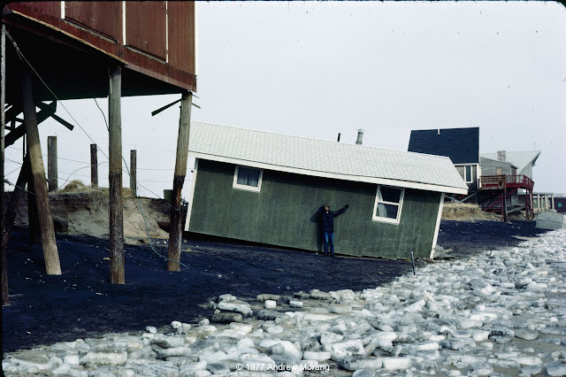
Homeowners often hired contractors with bulldozers to push sand up to the houses. I think this was technically illegal, but do not recall if there was any legal action. 

Different states use different criteria to define private property versus public land. Public sand does not belong to private landowners, even if they think it is theirs to use. In effect, what is the definition of shoreline? Geographers and politicians have argued about this for over two centuries. If you are interested in the topic, NOAA has posted a list of shoreline references. Shalowitz' Shore and Sea Boundaries is a defining reference and summarizes technical and legal aspects of determining maritime boundaries in the United States. We will see more controversy related to shoreline definition as beaches retreat on most US coasts in the face of rising sea level (as a result of the climate change that millions of delusional Americans deny is underway).

In the next article, I will write about the Great New England Hurricane of 1938

Oops, sometimes we had to shovel the car out of the snow to get to the beach
Beginning of the great Northeastern Blizzard of '78 (flash photograph)

The Northeastern United States Blizzard of 1978 dropped record amounts of snow throughout New England. The Boston area was closed to outsiders for almost two weeks. We did not fare too badly in southern Rhode Island. We lost electricity, but we had down sleeping bags and did not have any issues. We cooked on a Bleuet GAZ camping stove. Those were the days.

The photographs above were all Kodachrome 25 or 64 slides, most from my Nikkormat FTn camera or my Leica IIIC, which I still use. I scanned them with a Plustek 7600i scanner operated with Silverfast Ai software.


Friday, November 5, 2010

The Beach in Winter

The beach in winter is a lonely place. The beach houses and cabanas seem to be waiting for happy families and energetic children to return. In the off season, bathhouses always interested me because of their symmetry. They have a transient appearance, but yet many are decades old.


These first two photographs are from the beach club at Watch Hill, Rhode Island. The bathhouse is built on a narrow sand spit, Napatree Point, that sticks out west into Long Island Sound. The second scene is looking north into Watch Hill Cove.


Drive a few miles east along the Atlantic shore of Rhode Island and you reach Misquamicut State Beach.


The parking lot view is a bit utilitarian, but the ocean side of the bathhouse is quite nice with its cheerful turquoise paint and expansive view of the ocean. The rows of sand fencing shows that the state workers are trying to trap as much sand as possible. Rhode Island's beaches have been retreating (eroding) for decades, but I am not sure what the rate has been here at Misquamicut.

Atlantic Avenue near Misquamicut has the normal beachy collection of motels, convenience stores, and restaurants. The one above has seen better days.

Rhode Island somehow avoided the most crass examples of late-20th century beach architecture, such as the giant pink shops selling swim suits and tee shirts. The monstrosity above was the former Souvenir City near Biloxi, Mississippi, in October 2006, over a year after Hurricane Katrina devastated the Gulf Coast.


Let's move Across the Atlantic to the North Sea coast of the Netherlands. The cheerful little dressing cottages above are are on the island of Texel, near the resort town of Da Koog. Da Koog is popular with German tourists. They did not often see Americans there.

Now let's move south to the Gulf of Corinth in Greece. There is minimal tidal variation in the Gulf, but it experiences seiching (water set-up caused by steady wind pushing the water to one end of the basin). This is also a very seismically active area with opposite sides of the Gulf experiencing uplift or sinking at different rates.

This is a night club/bar near the town of Nerantza, a few kilometers west of Corinth. Note the umbrella posts in the water.

Even lake beaches have bathhouses. This is the Bains des Pâquis, in Geneva, Switzerland. The bath house and a small beach were built in 1872 on a pier that projects into Lac Leman. The present structures were rebuilt in 1932. The water is cold, even on a hot summer day. It is a relaxing way to spend a day if you are passing through Geneva.

There is a popular and modest-priced cafe at the Pâquis. If you don't finish your meal, a sparrow or duck will finish it off.
2018 update:  Here is a summer photograph of the Bains des Pâquis (scan from a Kodachrome slide, taken with a Leica M2 rangefinder camera using a 20mm f/5.6 Russar lens).