Showing posts with label Waterways Experiment Station. Show all posts

Saturday, July 7, 2018

The Mississippi Basin Model - 1975 Booklet

Dear Readers,

I have written about the famous US Army Corps of Engineers Mississippi Basin Model before. If you click on the link and scroll to the bottom of the article, you will see links to older posts. The City of Jackson neglected the model for over a decade. But the Friends of Mississippi River Basin Model (Facebook: @FriendsofMississippiRiverBasinModel) are now cleaning the trees and debris at the site in Buddy Butts Park in Jackson. 


Aerial view of the Mississippi Basin Model with red outline showing area that has been cleared and cleaned as of June, 2018 (from Friends of the Mississippi River Basin Model).

For more information on the design, purpose, and background, the Waterways Experiment Station prepared a booklet that described the Basin Model. The booklet is a .pdf file that the link will open. It is well-written and illustrated; please take time to read it.


Monday, July 10, 2017

Detritus of the Move - Changing Offices at WES

In mid-2004, the laboratory where I worked moved into a new building. I managed to be out of town during the move (that was good timing!), but upon return to Vicksburg, I wandered around the old building to see what was left. It was largely junk that no one wanted to take to their nice and clean new offices - debris that probably should have been dumped a long time before. My coworkers were scientists and engineers; we are the type of people who keep stuff - forever (just in case we might need it...).
9-track tapes used with older VAX-VMS computer systems. For decades. this is how you sent data to other scientists. You have seen tape reels like this in news articles of the Gemini and Apollo space missions. 
We still used these sturdy analogue telephones. The wheel on the right is a Kodak Carousel slide tray.
The manuals on the table are for Microstation software. In the 1990s, Microstation made you buy  proprietary workstations to run their software - at extortionist prices, of course.
A particle-board ersatz wood-grain computer station. Furniture at its best.
Good debris on another example of particle-board furniture. Definitely not worth moving.
That was a good Scotch tape dispenser!
Compared to the 9-track tapes, here we have "modern" data storage media: compact disks (CDs). The CD was originally developed as a music media to replace LP records, and a CD of about 640 mbytes could include the entire contents of Symphony 9 by Beethoven in uncompressed format.
More of the Microstation manuals and the proprietary Microstation keyboard. This software was used for bathymetry charts and analysis of sounding data. 
Trash is often interesting. Here we have Polaroid instant 35mm film and boxes of diskettes. 
Finally, a sad plant. "Take me with you!"
Photographs taken with a Leica M2 rangefinder camera on Kodak BW400 film. This was a black and white film that could be developed in C-41 chemistry, like any common color print film.


Wednesday, November 25, 2015

Mississippi River Basin Model - continuing decay, November 2015

The former U.S. Army Corps of Engineers' Mississippi Basin Model in Buddy Butts Park in Jackson, Mississippi, remains abandoned and neglected by the City of Jackson. As you might expect, the site is more and more overgrown and vandalized than ever. On this visit, my friends and I explored some of the buildings, which are gradually collapsing.
The first building, next to the water tower, was a pump house partly built over a sump. The catwalk is still intact despite the roof collapsing.
 A steel shed once contained air compressors and other machinery of unknown purpose.
This building once contained the Stevens chart recorders and may have been an executive control center for the model. I showed photographs of the old Stevens recorders in my 2010 article, but all have disappeared now.
These shelves once contained rolls of paper with holes representing some sort of coding (octal?). The flow of water via electrical or pneumatically-actuated valves was controlled by these paper strip charts.
This is one of the inflow controllers. I wish it was intact and wish I knew how it worked.
My friends and I came across another building that we had not explored before.
This building contained the remains of two huge air compressors. I am still not sure exactly how the compressed air was used, but it had something to do with the pneumatic controllers and the chart strip recorders.
This viewing platform was once used by tourists who visited the site. In the 1960s, the Basin Model was a popular tourist attraction (as was the Waterways Experiment Station before 9/11). I have read that many of the former German prisoners of war who worked on the site in World War II came to see the functioning model.
The model is a peaceful place on a quiet Autumn afternoon. Visit it soon before the buildings and concrete terrain elements are completely overgrown.

For some earlier articles, please click the links:

Photographs taken with a Fujifilm X-E1 digital camera with a Fujinon 27mm f/2.8 lens. Raw files processed in PhotoNinja software.

UPDATE JULY 2017:  A volunteer organization has been formed to clean and clear the site and develop it as an education/interpretive center. Readers interested in participating in the cleanup work, please contact: 

Sarah McEwen
President, Friends of the Mississippi River Basin Model
601-376-9131
Twitter: @MSRiverBasinMod
Facebook: @FriendsofMississippiRiverBasin Model

Saturday, January 12, 2013

Mississippi Basin Model construction and instruments

Regular readers may remember my earlier posts about the Mississippi Basin Model from early 2010, July 2010, and Dec. 2010. This was the most comprehensive hydraulic model ever built, meaning it covered the largest land extent of any model. The Corps of Engineers also built a Chesapeake Bay Model and one of San Francisco Bay. The Chesapeake model only had a full operational life of three years and is now gone.  But the San Francisco model still exists and is open to visitors in a warehouse in Sausalito.

Building a model like this is a complex project requiring precise scaling and ultra-precise shaping of the terrain. I found some photographs that help explain how a scale physical hydraulic model like this is constructed.
In the first photograph, metal templates that show the topography have been laid out across the soil at specified intervals. The templates usually have vertical exaggeration, such as 1:10, meaning vertical distance is scaled 10 times greater than the horizontal scale. Then the soil is moved and shaped to approximately match the templates.

At the Mississippi Basin Model, the original earth work, excavating canals, and installing piping was performed by German prisoners of war.  The Germans were repatriated in 1946, and civilian employees completed the rest of the model.  The template method of shaping the terrain was used between 1946 and approximately 1953. But the expansive soil in the area required a shift to the contour method of construction (not shown in these photographs).
In the second photograph, the workers are carefully pouring concrete and shaping the surface to exactly match the top of the templates. This is painstaking work requiring years of experience. The labor, time, and space requirements underscore why building physical models is so expensive.
This is an electronic water-level follower, meaning an instrument to measure water level. Notice that electronic circuits means vacuum tubes!
Finally, here is one of the Stevens chart recorders that plots the water level over time. As the paper drum turns, an ink pens moves up and down on the guide rails.
This is a January, 2010, photograph of one of the controls rooms at the Basin Model. Since then, all the Stevens recorders have been removed, probably stolen.

Historical black and white photographs courtesy of the Coastal and Hydraulics Laboratory, Engineer Research and Development Center, US Army Corps of Engineers.

Monday, May 14, 2012

Demolition of Shelter 3 at the Waterways Experiment Station, May 2012 Update

Some readers may remember a 2011 post showing  the interior of Waves Shelter 3 (Building 3100) at the Waterways Experiment Station, in Vicksburg, Mississippi.


After electrical work, removal of some trailers, and rerouting optical cables, the demolition is finally underway. I am surprised what a small work crew can accomplish the project. One or two workers use cutting torches to cut bolts, and the diesel machines literally pull down big sections of roof and girders.


Dealing with the debris is harder work. The metal is cut with big pincers, and the material is placed in large open dump trucks, whence it is taken off station. This makes me realize what an immense amount of junk and waste we generate in our modern society. An old wooden house eventually collapses and rots, but this steel must be actively recycled (melted and reused) or else it will linger in landfills for centuries.

Photographs taken with a Fujifilm F31fd digital camera.

Wednesday, April 4, 2012

Demolition of Hangar 3 at the Waterways Experiment Station, Vicksburg, Mississippi

Hangar 3 was one of four aircraft-type hangars acquired by the Waterways Experiment Station (WES) sometime in the late-1940s or early-1950s. When complete, it covered 58,700 square feet. Recall that WES is the research and development laboratory operated by the US Army Corps of Engineers in Vicksburg, Misissippi. After World War II, a lot of surplus military equipment and infrastructure was available, and I assume WES acquired these hangars from the Army Air Force or equivalent for free or at low cost.
Two of the hangars were used as shelters to cover hydraulic models. Hangar 3 was transferred to the Coastal Engineering Research Center (CERC) in 1983. CERC has now been incorporated into the Coastal and Hydraulics Laboratory (CHL). As the years go by, fewer and fewer physical hydraulic models are used due to high construction cost, water use, and time. Therefore, there is no need for some of the hangar space.
Not much is left in this interior photograph. But you can see why a hangar is a brilliant design: the strong arch allows a vast floor space to exist without the need for central pillars or supports. I assume originally these hangars could be lengthened as needed by simply adding more arch girders and roof panels.
The blue woven matting was used for wave dampening in hydraulic models.
The hangars were equipped with serious electrical supply (for pumps) and bright lights. During tests, paper confetti was thrown into the water and photographed with time-lapse photography. The cameras were mounted on walkways suspended way above the models.
It does not take long for a commercial demolition crew to tear down the metal panels with a cutting machine. So sad...

April 9, 2012 update: My wife informed me that the roof is totally down.

All photographs taken with a Fuji F31fd compact digital camera.
June 2015 update: Hangar 4 has also been demolished to make way for the new headquarters building.

Sunday, July 31, 2011

Shelter 3 at the Waterways Experiment Station, Vicksburg, Mississippi

In the previous article, I described how the Waterways Experiment Station in Vicksburg, Mississippi, formerly conducted numerous tests using hydraulic models. Some were outside, like the famous Mississippi Basin Model in Jackson (see the December 2010 update). But most models were inside shelters or hangars to keep them out of the weather and limit dirt and debris.
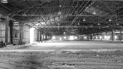
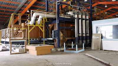
Shelter 3 is an example. There is nothing glamorous about it; it is just a steel roof over a dirt floor. When complete, it covered 97,300 square feet of model space. Most of this shelter will be torn down soon, so the models were dismantled and miscellaneous equipment was moved out in 2010.

(Notice the "blooming" around the windows and doors. This is diffraction that occurs when the source of light is many stops brighter than the main part of the image. It is worse with small-sensor point-and-shoot cameras. High-speed black and white film would have responded similarly because of the thickness of the emulsion, but a thin, low-speed film like Kodak Panatomic-X would have minimized the blooming. The quality of the lens coating and the number of elements also affects diffraction.)
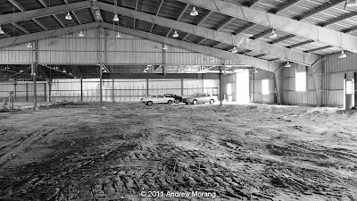
Until the building is demolished, it serves as a convenient place for employees to park cars. In a 1949 aerial photograph of the lab, a low wood shelter occupies this location, but in a 1981 photograph, this steel building is present. Many of the World War II-era wood shelters were replaced with steel in the 1960s.
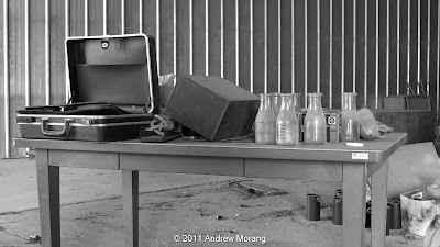
A few treasures remain. A sizable collection of file cabinets and map cases contain old project files. As time goes by and technicians retire, fewer and fewer remain who remember what the files pertain to. It is unlikely that a hydraulic model would ever be rebuilt, but most Corps of Engineers projects, such as locks, dams, and waterways, last for centuries, so the data in the files may be of value in the future. But how will these files be stored and organized? Eventually the bugs and mildew will eat the paper if they don't move the files to a climate-controlled space.
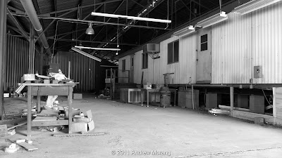
There is still one model in the north part of the shed, but I have not seen it used in a long time. It was a section model of the Dalles on the Columbia River. You see a number of odd little footprints in the soft dirt, probably raccoon. There are also fox on station
The south side of the shelter was used by a joint US Army Corps of Engineers and US Geological Survey program that developed and calibrated river sediment samplers. Measuring how much suspended sediment moves down rivers is difficult and labor-intensive because field crews have to cross the river and collect water samples at various depths. Bedload samples are even harder to collect and calibrate.
For the field work, they used sturdy Army Bridge Erection Boats. These were sent away to some other Army base. I like strange heavy-duty equipment like this.

All images except the last (the boat) were taken with a Panasonic G1 digital camera with Lumix 14-45mm lens, tripod-mounted. The in-camera black and white mode is very nice, with results as good as reprocessing the RAW file.

Update April 30, 2012: The shelter is actively being dismantled.