|
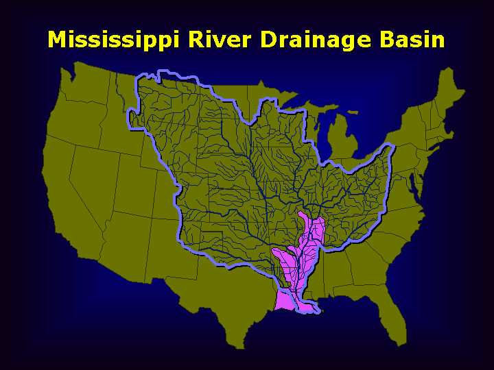
| Mississippi River drainage area (from US Army Corps of Engineers). Pink shows the area protected by the Mississippi River &Tributaries Project |
Before the mid-1800s, the Red River joined the Mississippi about 45 miles northwest of Baton Rouge, Louisiana, at latitude 31.1 degrees north. By definition, the Red was a tributary because it added its water to the main river. Just a short distance to the south, some water diverted off the main channel into the Atchafalaya River, which carried the flow to the Gulf of Mexico. Therefore, the Atchafalaya was a distributary because it carried water away from the main channel.
 |
| From US Army Corps of Engineers |
By the early 20th century, the Atchafalaya had been cleared and dredged to create a Federal navigation project. Dredging continued to improve navigation. But, a serious problem developed: during the early years of the 20th century, the Atchafalaya channel naturally scoured (became deeper) and proceeded to capture an ever greater percentage of the Mississippi's total flow. The reason was geological: The distance from Old River to the Gulf of Mexico via the present river channel past Baton Rouge and New Orleans and ending at the present Balize delta was about 300 miles, while the distance along the Atchafalaya waterway was only 140 miles. This meant the new route was steeper and therefore more efficient. From 1880-1950, the percentage of Mississippi water flowing down the Atchafalaya increased from 7 to over 25 percent, and river hydrologists predicted that by the 1970s, the Atchafalaya would capture almost all the flow (Reuss, 2004). Under natural conditions, this type of channel shifting occurred about every 1000 years, but for a modern industrial economy, such a shift would have disastrous economic consequences.
Consider what might happen: New Orleans would lose its fresh water supply. The many petrochemical plants and the nuclear power plant on the river between Baton Rouge and New Orleans would lose water supply. It might be close to impossible - or vastly expensive - to maintain a deep-draft navigation channel suitable for ocean-going vessels to reach Baton Rouge. Note: Baton Rouge is now a deep-draft port, meaning one suitable for ocean-going vessels. The reason this is possible is the scouring action of the Mississippi flow, which flushes much of the sediment load out to sea, leaving a deep channel.
In the 1954 Flood Control Act, Congress authorized the Corps of Engineers to build structures to control the flow of water down the Atchafalaya. The Act also authorized future appropriation for navigation locks. The flow was to be maintained at 30 percent of the total at that latitude. This is complicated to compute because it includes the input from both the Mississippi and Red Rivers. Therefore, the diversion from the main trunk of the Mississippi is somewhat less than 30 percent, depending on how much water is coming down the Red. The following figure shows what Congress intended.
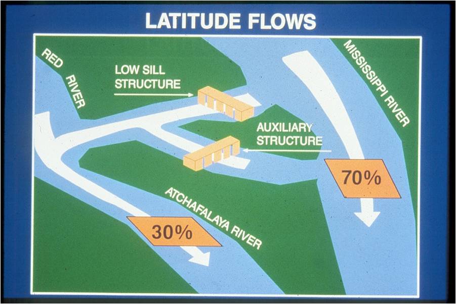 |
| From US Army Corps of Engineers |
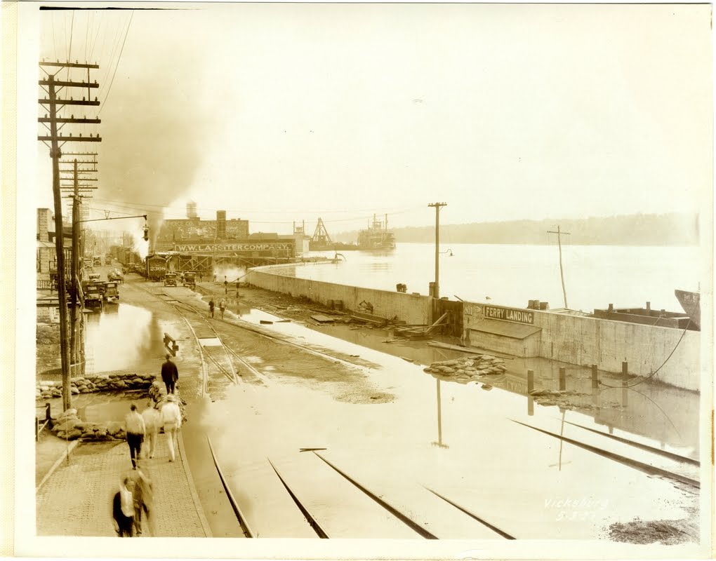
Photographs. Driving south on Louisiana 15, which follows the levee along the west side of the Mississippi, the road crosses a bridge at the Sidney Murray station, then crosses the Overbank Structure, and finally reaches the Low Sill Structure.
Upstream side of the Sidney A. Murray hydroelectric plant. This 2009 photograph was taken at low water. The intakes for the turbines are way below the water level and there is little to see for the casual visitor..

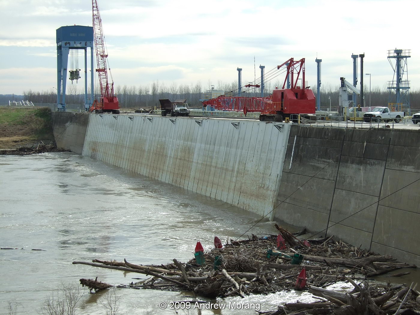
The downstream side of the Overbank Structure at low water on January 19, 2009.

One of the bays in the Overbank Structure. During floods, wood boards or batons can be lifted one by one to control the flow of water. In the 2011 flood, leakage past the boards amounted to about 50,000 cubic feet per second (cfs).
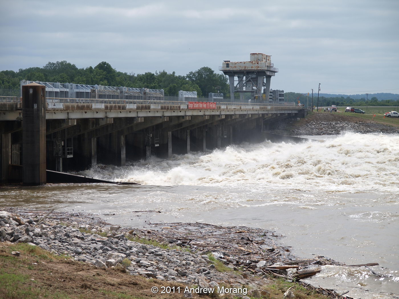
Downstream side of the Low Sill Structure, 14 May, 2011, with flow of approx. 200,000 cfs.

The upstream side on the Low Sill structure. Water this high is a very rare event; it may be decades before we see it as high again. During the flood of 1973, a great scout hole formed on the south side of the structure (the far side in this photograph). Engineers feared the structure might collapse, which would have led to the abrupt switching of water flow down the Atchafalaya waterway. If this had happened, a new structure could have been built in summer, when the water was low, but it would have been technically difficult and very expensive. Congress would have had to appropriate emergency funds. Months of excess flow down the Atchafalaya waterway would have caused many economic, sedimentological, and environmental consequences.

The vertical panels are the gates. A crane moves along a track, and the operators raise or lower the panels into the concrete slots in the dam. The amount of water is controlled by how high the panels are above the concrete bottom. Water flowing along the bottom of the concrete channel flushes sediment through the system into the outlet canal and, ultimately, into the Atchafalaya.
The next structure to the south is the Auxiliary Structure. This was built after the 1973 flood almost destroyed the Low Sill Structure and engineers realized that that another structure was needed to channel some of the water to the Atchafalaya. Construction began in 1981 and was completed in 1986.

Downstream side of the Auxiliary Structure, 14 May 2011.

One of the the six tainter gates. These are steel arches fixed to trunnion blocks and lifted by steel cables. In this photograph, the gates are up 23 ft, resulting in total flow of 230,000 cfs. These gates can be controlled more precisely than the rectangle steel panels used in the Low Sill Structure.
The operators have to coordinate with the hydroelectric plant to adjust the water flow through all the structures. On May 19, the Mississippi was flowing at about 2,000,000 cfs, so the hydro plant, Overbank, Low Sill, and Auxiliary released about 600,000 cfs to the Atchafalaya, maintaining the 30/70 percent ratio.

Wood and flotsom get jammed up against the gates, and the raft often contains some interesting cargo. The cables hold up the gates and go up into the structure to heavy-duty electric winches.


The morning I visited, the gate operators and a ranger hoisted up a boar that had gotten stuck on the log raft. They said they were going to feed him corn for a few weeks. Sounds like an upcoming BBQ and plenty of bacon.
References
For a long but engaging description of the topic, I suggest a February 23, 1987 New Yorker article by John McPhee titled "The Control of Nature, Atchafalaya": Control of Nature
A shorter summary was written by Alexis Madrigal for a May 19, 2011 article in The Atlantic:
What We've Done
For a more scholarly treatment: Reuss, M. 2004. Designing the Bayous, The Control of Water in the Atchafalaya Basin, 1800-1995. Texas A&M University Press, College Station, TX, 474 p.
Acknowledgments
Thank you to New Orleans District Corps of Engineers and the operators of the Old River Control Structure for hosting tour groups from the Waterways Experiment Station in 2009 and 2011. We appreciate the time they took to show us around.