Friday, October 16, 2015

TB Sanatorium, Parnitha, Athens, Greece

Mount Parnitha (in Greek, Πάρνηθα) is a mountain about 30 km north of downtown Athens. When I was a child, it was a common Sunday outing to drive up the winding mountain road to the upper reaches of Parnitha to play in the snow of just enjoy the dense forests. We always passed a hulking old hospital that my parents said was a former sanatorium. In the 1950s, the memory of tuberculosis (or TB) was still fresh in many people's minds. Before the era of antibiotics, a long rest in an environment with clean air was the only hope for TB sufferers (and even then, the recovery rate was low).
A hospital on Parnitha was first was built in 1912 to treat patients suffering from tuberculosis. The facility treated many prominent citizens of Athens over the years. Unfortunately, despite the best efforts of doctors and the purported benefits of the fresh air in sanatoria, in the early 20th century, over 50 percent of patients died within five years. The first successful immunization against tuberculosis was based on attenuated bovine-strain tuberculosis, known as the bacille Calmette–Guérin (BCG). The BCG vaccine only received wide acceptance in USA and Europe after World War II. Thanks to public health initiatives, tuberculosis was largely eradicated from most of Greece and the Parnitha hospital closed in the 1950s or early 1960s. The building at the site is newer than 1912, I guess a reconstruction from the 1950s.
Around 1965, the Greek National Tourist Organization bought the hospital and renovated it as part of the now-defunct Xenia hotel chain. What a disgusting concept: a TB hospital as a hotel? 

The Xenia hotels were a major infrastructure program in the 1950s and 1960s, when Greece wanted to enhance its tourist potential. After the devastating civil war that ended in 1949, Greece lay in ruins and only major cities had hotels. The Xenias were often built in beautiful locations near archaeological sites. Many were of post-war modernist architecture. But they were government-run, and by the 1970s (even the 1960s) were hopelessly outclassed by commercial hotels. I recall drafty, echoey entry halls, erratic hot water, and grim breakfasts that featured stale bread, Nescafe, and a disgusting Tang-like orange drink. According to Wikipedia, the Xenia program was terminated in 1983. Many of the concrete buildings have not aged well, and they often looked out of place in towns among classical stone buildings.
The intrepid visitor ascends the crumbling steps into what was once the main entry hall. Some of the carpet is still there. I processed these photographs in color to show the red and blue carpeting, probably not very elegant even in the 1960s.
I suppose in the past, the public rooms might have been reasonably cheerful on sunny days.
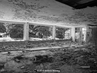
The hallways are long and gloomy, and the concrete and plaster is spalling and crumbling into powder.
Some of the graffiti is pretty imaginative and worth showing in color.
I did not see much furniture. Some bloggers have shown kitchen equipment, but I was hesitant to explore too deeply by myself. My nephew said drug activity happens there, but on the weekday that I visited, all I saw was some other photographers. Still, I decided to not venture alone into the dark cellar.
In 2007, a devastating fire burned a wide area around Parnitha. The fire destroyed rare Greek Fir and Aleppo Pine. Since then, the fallen timber has been removed, leaving a wasteland of bare rock and thin soil. The forest will take decades or centuries to recover. The odd sculpture garden used fire-damaged tree trunks. 

The lower photograph shows the Regency Casino Mont Parnes, minus the once-beautiful forest. The casino and hotel have a cable car, but the site is so remote from Athens, I am surprised it can remain in business.

Click the links below for other articles on the TB sanatorium:

The Greek Reporter

Deserted Places blog (from 2012)

PBS (Public Broadcast System) aired an excellent documentary in February, 2015, on tuberculosis in America, titled The Forgotten Plague. I recommend it highly.

I took these photographs taken with a Panasonic G3 digital camera, with RAW files processed in PhotoNinja software. I drew the map with ESRI ArcMap software.

UPDATE:  For some 2016 photographs on Kodak Tri-X film:  https://worldofdecay.blogspot.com/2016/12/the-tb-hospital-on-parnitha-greece.html

Monday, October 12, 2015

Lower 9th Ward in Film - Hurricane Katrina 10-year anniversary

This is the fifth is a series of posts about the damage caused by Hurricane Katrina on August 29, 2005. The storm made landfall as a Category 3 hurricane at Bay St. Louis, Mississippi, with sustained winds of more than 125 mph. Because of a breach in the Industrial Canal, by 09:00 AM CDT, there was 6–8 feet of water in the Lower Ninth Ward of New Orleans. People had been warned to evacuate, but many did not heed the warnings or were unable to leave, requiring days of heroic rescue efforts by the National Guard and Coast Guard.
The paint marks on the buildings show where a rescue team inspected the house and recorded what they found or did not find.
I took these photographs in October of 2006 in the Holy Cross area of the Lower Ninth Ward. The historic cottages had been flooded, but the water drained out and most looked like the were reasonably intact. Sheetrock had to be cut out, but the cypress boards were fine.
These photographs are scanned from Kodak B+W film, exposed in a Leica M3 rangefinder camera with 35mm and 50mm Summicron lenses. The B+W film scans well and is fine grain - I need to use the current equivalent more often. I love film, especially black and white; it looks different than all-digital photographs.
By 2006, some residents had returned and a little activity was ongoing. I think the SnowBalls truck was operational.
Please click any of the photographs to enlarge them or use the search function to see earlier posts about Katrina damage.

Tuesday, October 6, 2015

Hurricane Katrina 10-year anniversary - return to the Lower Ninth Ward (New Orleans)

On the tenth anniversary of Hurricane Katrina, this the fourth in a series of articles showing some of the damage in New Orleans. 
In December of 2006, I returned to New Orleans with some out-of-town visitors. I took them to the Lower Ninth Ward, whose damage and general state of abandonment was still a common topic in the news media at the time.
Derbigny Street was still a mess. We found an abandoned Juke Joint with pool table and cassette tapes still in place.
On Reynes Street, an abandoned restaurant had not been cleared out. It was sad - this was once someone's business, probably their dream of making a better life for themselves and their family.
A church on Forstall Street had a plea for restoration.
Further west, in the Upper Ninth Ward, a traditional New Orleans cottage on Chatres Street was in poor condition. The roof had lost many of its asbestos shingles. Many of these asbestos roofs were installed in the 1910s and 1920s because the tiles were fireproof and much safer than wood shingles.
The French Quarter, which had not flooded, had plenty of tourists, and the cottages were decorated for the Christmas season.
Lafayette Cemetery, in the Garden District, is the oldest of the seven municipal cemeteries in New Orleans. The cemetery was first surveyed in 1832 and laid out with two center aisles in a cruciform (cross) pattern. Save Our Cemeteries is an organization dedicated to preserving and documenting the history of New Orleans' historic cemeteries.

All photographs taken with a compact Sony DSC-W7 digital camera (a very competent 7 megapixel camera).

Sunday, October 4, 2015

Hurricane Katrina 10-year anniversary: The Holy Cross District, New Orleans

The neighborhood of New Orleans east of the Industrial Canal and along the banks of the Mississippi River is known as the Holy Cross District, named for the historic Catholic school of the same name. This was a subdistrict of the Lower Ninth Ward. Further east or downstream along the Mississippi is the area known as Arabi. The Historic Districts Landmark Commission has an information page on Holy Cross. The photograph above shows the Industrial Canal in November 2006.
During Hurricane Katrina, the northern part of the Holy Cross subdistrict, the blocks near St. Claude Avenue, were inundated just as severely as the blocks in the Lower Ninth Ward north of St. Claude Avenue. But as you proceed south, the land level rises until it is above sea level near the Mississippi River levees.
This topographic change was reflected in the architecture. The houses in the north were mostly on slab foundations and were largely post-Hurricane Betsy vintage (1965). But closer to the river, many houses were historic late-1800s wood cottages with typical elegant New Orleans architectural details. These had survived for a century because, during floods, they had either not been inundated or had suffered only minor water damage. Consider the building style: a slab house is right on the ground and doomed if it floods. A post-and-beam house is already two, three, or more feet off the ground, and if it floods, as soon as the water recedes, the water pours out through the floor boards. Most of these older houses in this area were made of cypress planks because the early builders knew that cypress resisted water and rot.
Some of these cottages are quite striking in their simple symmetry and graceful proportions.
I don't mean to imply that there was not damage in the Holy Cross area, but it was less than the area further north.

Commercial companies (consisting of Mexican workers?) cleared debris out of houses. Children's toys, mattresses, clothing, moldy sheetrock, and other mess was still being piled in the streets a year after Katrina.

The markings showed where rescue workers checked the buildings for human or animal victims.

In 2006, we saw a few signs of business returning, as per this snowball truck and the recycler who stored things on the front porch.

This is one of the two Doullut Steamboat Houses, built by Captain Doullut in 1905. They are on Egania Street and are designated as historic landmarks.

Back to the Industrial Canal, we saw one of the largest metal scrap piles we have ever seen. This is where old wash machines, stoves, and school busses ended up after being retrieved from streets and houses. We were told that much of this metal scrap went to Bangladesh. You can tell the scale of the pile by the two Holy Cross school busses.

Ten years on, the Holy Cross area looks good, residents have returned, and rents are sky high. The school has moved to the Gentilly area, and many buildings have been demolished. The neighborhood is changing, and it is good to see the historic homes renovated and revitalized.

Photographs taken with a Sony DSC-R1 digital camera. This was an excellent digital camera with an APS-size sensor.